
Image
Wayne Johnson's suspicions were correct.
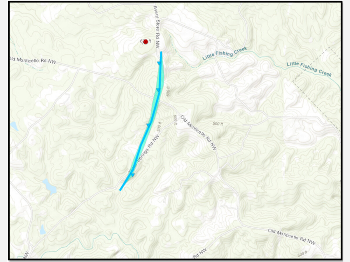
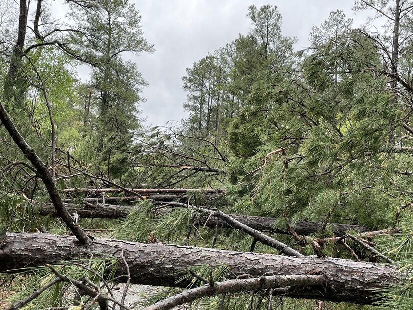
Baldwin County's EMA director suspected that a tornado may have touched down on the afternoon of April 5 in northwest Baldwin County. Roughly 100 trees were downed that day in the area of Avery Store Road and Old Monticello Road.
On Thursday, the National Weather Service concluded that the weather event indeed was a tornado. It marks the first tornado in Baldwin County since Jan. 21, 2017, which actually began began in Hancock County before busting into Baldwin.
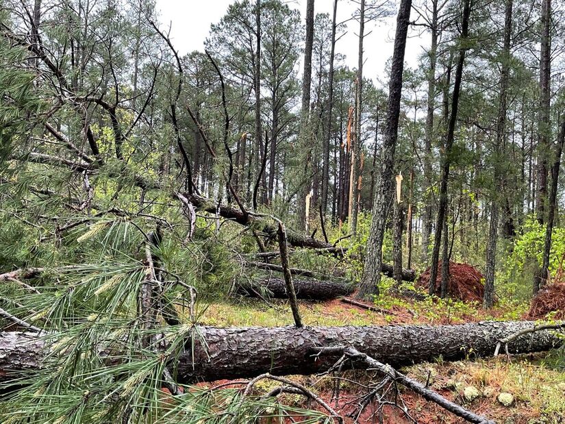
The tornado from earlier this month began roughly one mile west of the intersection of Old Monticello Road and Avery Store Road before crossing the intersection and downing more trees. It wasn't exactly a world record holder or the onset of the apocalypse, but it was still a tornado, the NWS concluded. Estimated peak winds were 75 miles per hour, the path was 1.72 miles long and 150 yards wide. The "start" time was listed as 4:01 p.m., which was actually four minutes before the NWS sent out a blanket "TORNADO WARNING" text message and scary-sounding ring to cell phone owners in Milledgeville.
The April 5, 2022 tornado was classified as an EF0, while the 2017 tornado was an EF1. Wrote the NWS back in 2017: "A National Weather Service survey team found that an EF1 tornado with maximum winds of 95 MPH and a maximum path width of 70 yards began in Hancock County just northeast of Deepstep Road, which is the Hancock/Baldwin County line. The tornado moved northeast parallel to Deepstep Road for less than a quarter of a mile before it turned east and crossed the road into Baldwin County. Several trees were blown down along this portion of the path. The total path length in both counties was around a half mile."
In terms of the April 5 tornado, the NWS wrote:
A BRIEF TORNADO TOUCHED DOWN WEST-NORTHWEST OF MILLEDGEVILLE JUST
AFTER 4PM ON APRIL 5TH. MORE THAN 100 TREES WERE REPORTED DOWN
AROUND A PROPERTY JUST SOUTH OF THE OLD MONTICELLO ROAD NW AND
AVERY STORE ROAD INTERSECTION, WITH ADDITIONAL TREES SNAPPED OR
UPROOTED ABOUT 1/2 MILE UP ALONG AVERY STORE ROAD. A WEAK TDS WAS
EVIDENT FROM RADAR AS THE CIRCULATION MOVED NNE.
There were roughly 24 tornadoes documented on April 5, with the overwhelming majority happening in Middle Georgia. The Baldwin County tornado was along the northernmost band of the weather system, and nearly all of the worst damage was south of here. Three tornadoes were documented in Laurens County, just because Laurens County always seems to have the most tornadoes. There was one in north Macon, one in Bonaire in Houston County, as well as one near the Twiggs/Wilkinson line. The strongest tornado from April 5 was recorded near Byromville in Dooly County, with winds reaching roughly 130 miles per hour along a path six miles long and nearly three football fields wide.

I was diagnosed in March 2017, but was running around from doctor to doctor before I finally got a result that I was free from MND ALS. Mine started on top and progressed into the bottom. I could walk very little but need assistance as I have no balance.
I was diagnosed in March 2017, but was running around from doctor to doctor before I finally got a result that I was free from MND ALS. Mine started on top and progressed into the bottom. I could walk very little but need assistance as I have no balance.

Patchy rain nearby, with a high of 85 and low of 74 degrees. Overcast in the morning, patchy rain nearby during the afternoon, clear in the evening, mist overnight.


Everything sounded so lovely until the end.
“We tried”
If that’s not disheartening idk what is. I feel the need to quote my mom here. “I can’t have nothin nice”. Wiser words were never said.
Oh! And for gods sake STAY HYDRATED if you want to save on hospital bills. I hate summer.
Member when the river was fun and didn’t get angry and take lives? You could float down hopefully by sunset with only burnt skin that was a problem for later you? Member when your biggest fear were all the scary gar lingering about?


loving that suit! That hippie has style and wears it well.